We will be visiting Nova Scotia for 8 days. We will be exploring the sites on Cape Breton Island, watching the tides at Fundy Bay off of Truro and checking out several sites in Nova Scotia’s capital city of Halifax.
Some facts about Nova Scotia: Nova Scotia is Latin for New Scotland. Nova Scotia was already home to the Mi'kmaq people when French
colonists established the first permanent European settlement in Canada and the first north of Florida in 1604. In 1497 explorer John Cabot claims Cape Breton Island for England. In 1534 Jacques Cartier claims the region for France. In 1867 Nova Scotia was one of the four founding provinces of the Canadian Confederation. Nova Scotia has a population of 913,462 and is 21,345 square miles. Nova Scotia’s motto is “One Defends and the Other Conquers”. License Plate says “Canada’s Ocean Playground”. The Province Flower is Mayflower, and Tree; Red Spruce, Gemstone; Agate.
DAY 68-70: SEPT 15-17 ~ CAPE BRETON ISLAND
Cape Breton Island is connected to the rest of Nova Scotia by a 4,544 foot rock filled causeway called Cansco Causeway. In the northern corner of the island is Cape Breton Highlands National Park with the scenic Cabot Trail looping around part of this national park as well as a large portion of the island. On the southern end of the Island is Fortress of Louisbourg National Historic Site with a restored village from 1744 and people in costume. We will be visiting and exploring these areas over the next three days.
After 5.5 hours and 266 miles we arrived at Baddeck Cabot Trail Campground located in the town of Baddeck on Cape Breton Island.
BADDECK
Baddeck is a resort community but retains the feel of a quaint village. It is on the shore of the Bras d’Or Lakes on Cape Breton Island. It got its name from the Mikmaq word abadak, which means “place with an island near. Gaelic is spoken here and old Highland Scottish customs are part of this area’s culture. You see many store and street signs in both English and Gaelic.

Alexander Graham Bell with Helen Keller and Anne Sullivan (Standing)
Alexander Graham Bell had a summer home here. He was drawn to this place because the scenery reminded him Scotland; his home and place of birth. He moved to Canada with his family when he was 19. He eventually moved and lived in Boston, where he worked on his many inventions. He became an American in 1882.
BADDECK CABOT TRAIL CAMP
Finally, a decent RV Park. This is a very nice place. Formally a KOA. The grounds are nice and tidy. No junk lying around or buildings falling down. Some sites out in the open, others under the trees. The restrooms are clean and decent. It is far off of the main road, in the forest with views of tree covered hills and next to Bras D’Or Lake. The showers are free and free WiFi with a strong and good connection. This is a nice, comfortable place.
 THE CABOT TRAIL
We drove all of the Cabot Trail (about 175 miles) in one day. It is a beautiful drive that winds around most of Cape Breton Island through stunning landscapes with views of the Atlantic Ocean. The Trail goes through the rugged highlands of the Cap Breton Highlands National Park and hugs the boundaries of the east side of the Park.
THE CABOT TRAIL
We drove all of the Cabot Trail (about 175 miles) in one day. It is a beautiful drive that winds around most of Cape Breton Island through stunning landscapes with views of the Atlantic Ocean. The Trail goes through the rugged highlands of the Cap Breton Highlands National Park and hugs the boundaries of the east side of the Park. 

The Cabot Trail was named after Italian explorer John Cabot (Giovanni Caboto) who reached the shores of Cape Breton in 1497. Cabot Trail was completed in 1932 and connects the previously isolated communities of the Acadian, Irish and Scottish settlements. There are many studios and galleries of glass, pottery, pewter, woodwork, etc along this road and we stopped at several of them to look at the locally made crafts that were on sale. It was a stormy day with dark clouds above, lots of wind and some low lying mists along this road. But it did not rain and the sun did peek out now and then and reflected off of the clouds and the way that reflected light hit the scenery made it quite magical. Everything was so green it felt like being in Ireland. There are a lot of aspen and maples along side the road. In a few weeks this area will be in flaming color.


A roadside oddity along the Cabot Trail:
GIANT FIDDLE
We made a trip into the town of Sydney to view the largest violin in the world. The Big Ceilidh Fiddle was commissioned for the opening of the Joan Harriss Cruis Pavillion. It is displayed at the harbor where all the cruise ships dock at. The Fiddle was created to recognize the fiddlers past and present who have contributed to the musical heritage of Cape Breton Island. Fiddle music was first brought to this area by Scottish immigrants more than 200 years ago.
The Fiddle stands 57 feet high, is made from painted steel, weights 8 tons and was fabricated over an 8-month period by Cyril Hearn, a Sydney artist and welder.
FORTRESS LOUISBOURG NATIONAL HISTORIC SITE
This 14,826 acre Historic Site includes a reconstruction of the massive fortress erected by the French in 1720 to 1745 to defend their colonies. About a quarter of colonial Louisbourg has been reconstructed to its 1744 appearance resulting in one of Canada's largest national historic sites.


DAY 71-72: SEPT 18-19 TRURO
Truro is a small town with a population of 11,765. It was once a large community of Acadian farmers. Acadians, by the way, are people who first settled in Canada. Most of them came from France and many of them married into the various Indian tribes that were across Canada. So a lot of them were mixed breeds and were considered aliens when the British came into the country and took over. The Acadians refused to swear loyalty to the British crown so many of them were forced off of their farms and also out of Canada. A lot of them came down into the US (before it was the United States) and settled in the New Orleans area.
We decided to spend a day here because there are some good Tidal Bore areas along the Fundy Bay where you can view the tides coming in.
After 4.25 hours and 171 miles we arrived at Scotia Pine Campground in Truro, Nova Scotia.
SCOTIA PINE CAMP
This is a very nice campground. Finally, a decent bathroom and shower. There are lots of permanent trailers in this park. They were all in their own section. The overnighters had a nice lawn area that was level and nicely manicured. The sites are spacious and level and laid out in neat rows. The grounds are tidy with no junk lying around. It has a pleasant atmosphere that is peaceful and relaxing, except when the train runs through on the tracks that are directly across the street from the park entrance a few times a day. This may keep us from returning.
 TIDAL BORE
 We viewed the tide coming in at a narrow point of the Cobequid Bay of Minas Basin (part of the Bay of Fundy), near Onslow to a Tidal Bore and watched the tide come in at 5:00pm. The Bay of Fundy has the largest tidal movement in the world. In some areas of the bay the difference between low tide and high tide can be 50 feet. Where we viewed the tide coming in was not very large, but it was interesting to watch the small wave coming up the point.
The next day we drove further out along Cobequid Bay to Burntcoat Head. This is an area where we could walk out onto the sea floor at low tide. We did not stay around to watch the high tide come in. That was going to be around 6pm and we were there early afternoon. The Guinness Book of World Records (1975) declared that Burntcoat Head had the highest tides in the world.

 Tree knots greeted us as we walked through the forest to the beach.
We stopped at a few galleries along the way and saw some of the local crafts. There are many farms and lots of corn fields in this area.

Calves in dog houses.
DAY 73-75: SEPT 20-22 HALIFAX
Halifax, the capital of Nova Scotia, has a population of 372,679 and is the largest city in the Maritimes Provinces. Halifax was also one of the first English settlements in Canada. It was founded in 1749 by Edward Cornwallis who recognized the site’s potential as a naval and military depot.
Two events happened in this city that Halifax will be recognized for. In 1912, Halifax was the center of operations for recovering the bodies from the Titanic and identifying them. 210 bodies were recovered and brought back to Halifax. An additional 116 bodies were badly damaged and could not be identified. Those were recommitted to the sea. Those bodies that were identified and claimed were turned over to their families. 150 bodies are buried in 3 cemeteries in Halifax. Half of those bodies remain unidentified. On December 6, 1917 a French munitions ship “Mount Blanc” fully loaded with wartime explosives collided with a Norwegian ship in The Narrows section of the Halifax Harbor. The explosion literally blew the Mont Blanc to pieces and leveled the north end of the city killing more than 2,000 people. An estimated 9,000 people were injured. All buildings and structures covering nearly 500 acres along the adjacent shore were obliterated, including those in the neighboring communities. The explosion caused a tsunami in the harbor and a pressure wave of air that snapped trees, bent iron rails, demolished buildings and grounded vessels. It basically emptied the harbor and then brought back debris and bodies. The Halifax Explosion remains the world’s largest man-made accidental explosion and will forever be remembered as “The Halifax Explosion”. The event is commemorated every year.
We will be spending three days in this city. There are many sites to visit and explore and we will be visiting the Maritime Museum, Natural History Museum, Citadel Historical Site and a spectacular city garden called the Public Garden. We will also visit an area called Peggy’s Cove that is located about 30 miles outside of Halifax. This is a quaint fishing village surrounded by giant granite boulders.
After 1.5 hours and 56 miles we arrived at the Halifax KOA in Halifax, Nova Scotia.
HALIFAX KOA
This is a very nice campground next to a pond that was lined with trees turning color. There was a dock on the pond with canoes to rent. There are spacious and clean showers that are in private rooms. Very nice. The sites for big rigs are out in the open. The smaller sites are under the trees. Those sites are spacious and private. The best sites overlook the pond, but they probably do not have full hookups. The WiFi was free with a good connection.

MARITIME MUSEUM OF THE ATLANTIC
This is a very nice museum. We visited it the day we arrived as it was open until 8pm that night. It is full of artifacts and is very informative. It had a permanent exhibit dedicated to the Titanic that includes a deck chair from the ship. There is also an informative exhibit on the 1917 Halifax Explosion with a history of that part of the city and recorded and taped interviews with survivors.

 In the picture behind the Titantic deck chair; walking are 2nd class passengers Elsie and Ada Doling (both survived), but the man beside them, Edwin Wheeler, died in the sinking.
The CSS Acadia is the museums largest artifact. The Acadia was the first hydrographic research vessel built to chart Canada’s Arctic and East coast waters. She is berthed at the Museum’s wharf and you can go onto it and see the 3 levels of the ship. We met Erik the Red, the ship’s 9 year old red tabby kitty, who keeps the ship free of rodents. There is an interesting story about Erik (see pictures).

 (Double click on picture to enlarge)
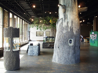
MUSEUM NATURAL HISTORY
The Museum of National History is a small museum with everything on one floor. It has a lot of interesting information on the province’s natural history. There are exhibits about marine life, geology, fossils, minerals, birds and mushrooms. There is quite a display of many species of mushrooms, all clay sculptures by a local artist Barbara Cronk.


The best part of the museum is Gus. Gus is an 88 year old Gopher Tortoise that was born and raised in Florida. He was bought for $5 by the director of the Nova Scotia Provincial Museum in 1942 and has lived at the National History Museum since that time.
PUBLIC GARDEN
The Public Garden is across the street from the History Museum and this is a beautiful garden with quite a collection of dahlias. This is a 17 acre garden that opened in 1867. This garden is one of the finest examples of a Victorian garden with walkways winding past flower beds, fountains, ponds, trees and shrubs. There is an oak tree that was planted by King George VI (Queen Elizabeth’s father). And despite summer being over, there were flowers everywhere! 

 PEGGY’S COVE
About 30 miles west of Halifax is Peggy’s Cove. Peggy’s Cove is one of many fishing villages built around the tight harbors along the south coast of Nova Scotia. Huge granite boulders are scattered through out the village and it is the most photographed area in the Maritimes. It all began with six fishermen. They had been fishing St. Margaret’s Bay for years and this cove was a safe place to land their catches and they were protected from the waves. They petitioned the Nova Scotia government for the right to settle here. In 1811, the province issued the first land grant of 800 acres to these fishermen and their families. The community of Peggy’s Cove was born. Who is Peggy? Some people will tell you it is a nickname for Margaret. But there is a romantic story about a young women named Peggy who was traveling to Halifax to meet her fiance when the ship she was on foundered on the rocks. She was rescued by local folk and when visitors went to see her they would say they were going to see "Peggy of the Cove".


This is a very peaceful and picturesque place. We walked along the granite boulders viewing the ocean and watching the waves hitting the boulders, checking out the lighthouse build on top of the boulders on the point and taking lots of pictures. We had lunch at a place in the village and checked out the shops.
A short distance from Peggy’s Cove is the site where Swissair Flight 111 crashed into the ocean. The communities of Peggy’s Cove and Blandford were central to the recovery operation following the crash. They were the first on the scene to look for survivors. All of the 229 men, women, and children aboard that flight perished on September 2, 1998. The cause of the crash was an in-flight fire that got out of control. The cause of the fire is still unknown.
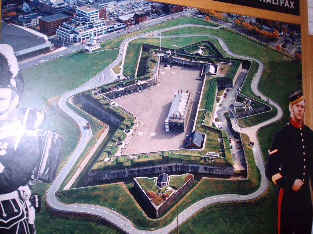
CITADEL NATIONAL HISTORIC SITE
The last place we visited was the Halifax Citadel. This is a 19th century fortification that is located on a hill overlooking Halifax. Since the founding of Halifax in 1749, Citadel Hill has served as the site of 4 different forts, each having been built during a time of war. The stone fort that stands today was constructed from 1828 to 1856, a period of 28 years. This star shaped fort was the last and strongest of the Citadels. It was occupied by the British until 1906 and then by the Canadian military until well after World War II. This is a huge place and in excellent condition. We got here at the end of the day and spent 1.5 hours walking around until it closed at 5:00pm.
The next day we left Nova Scotia and for the second time returned to New Brunswick to visit Fundy National Park and view more of the Bay of Fundy at high and low tide.


