
We drove out of the canyons into Idaho and wheat country. The countryside was flat with wheat fields everywhere. Some fields had new wheat that was green, others had more mature wheat that was the color of straw. It was nice scenery.

After 4.5 hours and 150 miles we arrived at Coeur d’Alene Campground in Coeur d’Alene.
COEUR d’ ALENE CAMPGROUND:
This RV park is a former KOA. We were misled with the location of this park as all the maps and GPS directions showed it being downtown next to Lake Coeur d’Alene. It is next to the Lake, but on the south end of the lake, 10 miles outside of town. It is an okay RV park. But the sites are small and crowded. The park was full; full of families with lots of kids so it was very loud and chaotic. But it is summer and Coeur d’Alene is a lake resort area and one of the most popular tourist destinations.


Please see our RV PARK REVIEW BLOG under IDAHO to see a review and more pictures of this campground. http://charleston-rv-park-review.blogspot.com/
COEUR d’ALENE:
Coeur d’Alene is the largest city in northern Idaho. French trappers named the city which means “heart of the awl”, a phrase describing them as shrewd traders. Coeur d’Alene has a population of around 34,000 and an elevation of 2,157. Despite its low elevation, Coeur d’Alene has severe winters with record snowfalls. Today Coeur d’Alene is a resort town with Lake Coeur d’Alene attracting thousands of tourists during the summer. Lake Coeur d’Alene is 25 miles long, 2.5 miles wide and has a 135 mile long shoreline. Sherman Avenue (named for General William Tecumseh Sherman who established an Army post here in 1878) is the main area where all the shops and fun are. Coeur d’Alene Resort, located on the shore of the Lake near Sherman Ave, is quite impressive and is the biggest employer of the residents in this city.


 |
| Coeur d'Alene Resort |
We really enjoyed this city and spent a lot of time checking out the shops and having lunch at a great place called SCRATCH. I also found a bead shop and purchased some beads to add to my collection of ‘great finds while traveling”. Also on Sherman Ave I found a hair salon and was able to get my hair cut and colored (which was badly needed).
We discovered the Mudgy Moose Trail while exploring the shops on Sherman Ave. “Mudgy and Millie” is a children’s story. The author, Susan Nipp, lives in Coeur d’Alene and the city inspired her to write the book. There are 5 bronze statues of Mudgy and Millie located around Sherman Ave, the City Park and near the Resort. Each statue tells a part of the story. While I was getting my hair done, Dave walked around finding all the statues and taking pictures. Check out their website: http://www.coeurdalene.org/mm/trail_map.html


The Farmer’s Market was going on that afternoon so we got to enjoy that as well.
Day 21, July 21 ~ SPOKANE, WA:
On our way to Idaho we drove through Spokane and did not have time to visit it. Since Spokane about 30 miles west of Coeur d’Alene, we decide to backtrack and spend the next day there.
Our first stop was CAT TALES ZOOLOGICAL PARK. This is a very small and privately owned zoo. It is a sanctuary and rescue center for exotic cats who were given up by their owners and wild cats that have been rescued, orphaned, or abandoned. It was quite impressive. They had a lion that we were told is “probably the biggest lion you will ever see”. He was once one of the MGM lions.


We found some meat lockers that were outdoors and lined up beside a building. We figured that the food for the big cats were stored there.


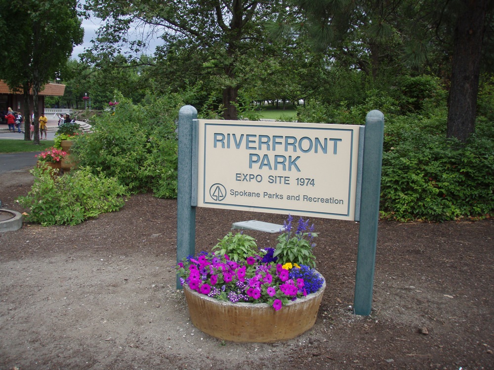
We visited RIVERSIDE PARK in the downtown area along the Spokane River. This was the site of the 1974 Expo. We saw the 1906 Looft Carousel and the Red Wagon, a giant Red Ryder wagon made into a children’s slide. Another stop was MANITO PARK where we strolled through the Japanese Garden.


We returned home and relaxed in our ‘home on wheels’ on our last night in Coeur d’ Alene. Coeur d’Alene is a fun city and enjoyed spending time there. This is a place that we will definitely return to.
On day 13 we will leave Idaho and head east into Montana for the next 8 days.
MONTANA FACTS:
Entered the Union on Nov 8, 1889.
Montana has a population of around 902,000 and is 147,138 square miles.
State Capital: Helena
State Nickname: Treasure State
State Motto: “ Gold and Silver”
State Motto (funny): Land of the Big Sky, the Unabomber,
Right-Wing Crazies, and Very Little Else
State Nickname: Treasure State
State Capital: Helena
State Flower: Bitterroot (1895)
State Bird: Western Meadowlark (1981)
State Animal: Grizzly Bear
State Tree: Ponderosa Pine (1949)
State Gem: Sapphire and Agate (1969)
State Song: “Montana” (1945)
DAY 13-20, JULY 22 – 29 ~ MONTANA
We left the wheat and potato country and headed into green open plains with rolling hills and snow capped mountains. As we entered Montana, we entered the mountain time zone and jumped an hour. There is no sales tax in the state of Montana!


Day 13-15, July 22-14 ~ WEST GLACIER:
Our first stop in Montana will be 3 nights at West Glacier. A small town just outside the west entrance of Glacier National Park. It was a long, very long drive. After 7 hours and 255 miles we arrived at West Glacier KOA.


We tried returning to the park entrance by the Inside North Fork Road (inside the park), but the road was closed due to cave-ins in a few areas. So we returned the way we came and did another pass on the Going to the Sun Road. This time the sky was crystal clear and the sun was bright and warm. So the lighting on the scenery was different but still beautiful.

As we entered Kootenai National Forest, we were driving along the Kootenai River and stopped and took pictures of the falls. It was more like rapids and spread across the river. The river was raging and it was very scenic.


Our first stop in Montana will be 3 nights at Glacier National Park. It was a long, very long drive. After 7 hours and 255 miles we arrived at West Glacier KOA.
Day 13-15, July 22-14 ~ WEST GLACIER:
Our first stop in Montana will be 3 nights at West Glacier. A small town just outside the west entrance of Glacier National Park. It was a long, very long drive. After 7 hours and 255 miles we arrived at West Glacier KOA.

WEST GLACIER KOA:
For a KOA, this is a very nice RV park. It has the environment of a luxury resort. It is in the woods, has manicured lawns and hanging flower pots. There is an outdoor café where they serve breakfast and dinner every day, and an ice cream parlor. The pull-thru sites are out in the open and are very spacious. The back-in sites are in the woods and are a bit crowded. We had a back-in site which was close to the neighbors, but we were comfortable.

Please see our RV PARK REVIEW BLOG under MONTANA to see a review and more pictures of this campground. http://charleston-rv-park-review.blogspot.com/
GLACIER NATIONAL PARK:
Glacier National Park was created in 1910. Waterton Lakes National Park in Canada was created in 1895. Both parks join each other. In 1932 the governments of Canada and USA linked the two parks as the world’s first International Peace Park. Today it is known as Waterton-Glacier International Peace Park World Heritage Site.

We last visited this park in May 2008. At that time the one road that ran through the park west to east; ‘Going to the Sun Road’, was closed for several miles at the highest point of the park due to being snowed in. This time that pass was open and we were able to drive the whole distance, 52 miles. The weather was perfect. It was sunny and warm with great views. There was some snow at the highest point and some dark clouds. And there were waterfalls everywhere! Lots and lots of waterfalls due to the snow melt.

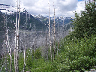
Fires in July 2003

McDonald Lake

Going to the Sun Road - See the car center right

Very close to the highest point of Going to the Sun Road, we drove past the “Weeping Wall”. And it was really weeping. It was like driving through water falls.
The next day we drove north along the Outside North Fork Road (outside the park) to POLEBRIDGE (about 25 miles north of the park entrance). Bill and Jesse Adair homesteaded the area and built Polebridge Mercantile in 1914. It still stands and is on the National Register of Historic Places. Today the “Merc” is famous for its fresh bakery and unique gifts. We purchased a loaf of bread and a dozen of the best cookies we have ever tasted.

We tried returning to the park entrance by the Inside North Fork Road (inside the park), but the road was closed due to cave-ins in a few areas. So we returned the way we came and did another pass on the Going to the Sun Road. This time the sky was crystal clear and the sun was bright and warm. So the lighting on the scenery was different but still beautiful.

Going to the Sun Road is that thin gray line running through the picture
About 2 miles before reaching the visitor center, the highest point of the road at 6,646 feet where Logan Pass Visitor Center is located, we came upon a “wildlife jam. We crawled for about 45 minutes while each car had to stop and take a picture of one lone mountain goat!!


We finally reached the visitor center and crossed the Continental Divide.

 |
| In the parking lot we found these two bright customized Chevy pickup trucks. They really stood out. |
We returned to West Glacier to our home on wheels to relax on our last night at Glacier National Park. The next day (day 16) we will continue east across Montana into Great Falls.
Day 16 & 17, July 25 & 26 ~ GREAT FALLS:
It was a scenic drive from West Glacier through eastern Montana. We stayed on country roads and drove past fields of hay, wheat, rolling hills and lots of cattle ranches.
After 5 hours and 194 miles we arrived at Dicks RV Park in Great Falls.
DICK’s RV PARK:
Dick’s RV park is a family owned park. The owner’s last name is Dick and they have been running this park for many years. The park was outside the city until they highway was built and blocked access to this RV Park. We had to drive around in a big circle (with the park always in our sight) to get to the entrance. More than half the residents of this park are permanent and work at the Malmstrom Air Force Base nearby. With the highway running next to the park on one side and the railroad tracks on the other side and the air port and the air force base nearby; well, it was not a quiet place to stay. Each of the two mornings the air force planes flew overhead. You could not see them, but you sure heard them. You could not talk and the trailer shook. But you did not hear them the rest of the day. At night the noise was bearable. I did not have to wear ear plugs. Our site was comfortable with lots of shade and grass all around and it was spacious and comfortable.


Please see our RV PARK REVIEW BLOG under MONTANA to see a review and more pictures of this campground. http://charleston-rv-park-review.blogspot.com/
GREAT FALLS:
The City of Great Falls. Meriweather Lewis and William Clark visited the Great Falls of the Missouri River in 1805. Clark mapped the area . You can see tributes to Lewis and Clark all over town and each year in late June there is a 3-day Lewis and Clark Festival where they do historic re-enactments and serve food that would have been eaten on their expedition.

Great Falls has a population of 56,690 and an elevation of 3,312.

The evening we arrived at Great Falls we drove nearby to find a place to eat. We found some very familiar restaurants that we have in Arizona, but not California; “On the Border” and “Macaroni Grill”. We had dinner at Macaroni Grill and discussed memories of the time we lived in Phoenix. In the same mall was a movie theater. We decided to see the newest and last movie of Harry Potter – Deathly Hallows II. As usual, a great movie with a happy ending.
It was also time to get our Ford worked on, so the next morning, before we started our day, Dave found a place and took the Ford in for a lube job. Now we are “good to go” for the next 3 or 4 weeks of our trip.
MISSOURI RIVER:
The Missouri River runs through the city of Great Falls. Lewis and Clark discovered 5 falls in this area of the Missouri and named them The Great Falls (now called Ryan Falls) Crooked Falls, Beautiful Cascade (now called Rainbow Falls), Colter Falls (which is now submerged), and Upper Pitch (now called Black Eagle Falls). When Lewis & Clark first arrived in this area he knew there were falls, but did not realize how many and how large and deep they were. So his team had to haul out their large log canoes (3 or 4 of them) with all their supplies and rig up a wheel and axles to put under the boats to bring them up the cliffs (this part of the Missouri and for several miles is in a canyon). They then walked along the cliffs to pass all the falls before they got back into the water.
 |
| Lewis & Clark Interpretative Center |
Much of the Missouri River here is just as it was when the Expedition came through and steps have been taken to keep it that way, even when the five dams were being built. The first was Black Eagle Dam, built in 1891. Rainbow Dam was built in 1910, which left the original cascade untouched, but submerged Colter Falls. In 1915 Ryan Dam was built at the Great Falls. Morony Dam was built in 1930, Cochrane Dam in 1958. The total output of these 5 dams is 220,000 KW.
We visited two of these dams and the falls. The water level was raised when RYAN DAM was built and RYAN FALLS is now 152 feet high.


We crossed over a suspension bridge to an island to get to the view point set up for viewing the dam and falls. A sign was posted at the end of the bridge warning everyone is to evacuate when they hear 6 horn blasts. When they open the spill way the island we were on will be under water, so we better move fast. But it never happened so we missed that adventure. That would have really sent that suspension bridge swaying.

BLACK EAGLE DAM was another dam and falls that we visited. Both these water falls were very powerful and very impressive.


Along the Missouri River between the two dams we visited the LEWIS & CLARK INTERPRETIVE CENTER. This place is worth seeing. This museum exhibits details of the Lewis & Clark Expedition from St. Louis to the Oregon Coast. It highlights the time they are in Montana.

We left the Missouri River and drove downtown to look for a place to eat. We drove by an impressive red brick building and saw a restaurant that might be a good place to eat. DANTE’s is in an old restored building that was build around 1910. I couldn’t find much info on the building. But the restaurant was attractive and impressive and the food was excellent!
BUFFALO HUNT PROJECT:
City Art Projects have been occurring in cities all over the country for the past several years. These are art projects where art teams or individuals paint life size fiberglass figures. These figures are displayed all over their city and are later auctioned off and the $$ is given to a selected charity. In our travels we always enjoy finding these fiberglass figures scattered about a city we are visiting. We have found Cats in Catskill, NY; American Quarter Horse in Amarillo, TX; Pigs in Little Rock, AR; Dinosaurs in Santa Fe, NM and many more. This year in Great Falls we found buffalo. This City Art Project was in 2005 and was called "Buffalo Hunt". It was sponsored by the C.M. Russell Museum.


C. M. RUSSELL MUSEUM:
While we were looking for a place to eat lunch in the downtown area, we found the C.M Russell Museum. Charles Marion Russell (1864-1926) was many things: consummate Westerner, historian, advocate of the Northern Plains Indians, cowboy, outdoorsman, writer, philosopher, environmentalist, conservationist, and not least, artist. Charlie Russell completed approximately 4,000 works of art during his lifetime. He was the first "Western" artist to live the majority of his life in the West. For this reason, Charlie knew his subject matter intimately, setting the standard for many western artists to follow. He also did bronze sculptures of cowboys, horses and other western figures. He was a collector of all things Western and Native American. His collections and artwork is displayed in his museum. The museum is build on the grounds where his home and studio are. This museum is a "must see" if you are ever in Great Falls, MT.


Our next destination is Billings, Montana.
Day 18 & 19, July 27 & 28 ~ BILLINGS:
Billings is in the bottom of a canyon with high cliffs surrounding the city. The city is next to Yellowstone River. The highway runs along the cliff top so you are driving in desert like country looking down into this oasis with a large river and dense trees. Billings is in the middle of this.


The Northern Pacific Railroad arrived in 1882, putting Billings on the map. Refusing to pay the exorbitant prices the landowners in nearby Coulson were demanding, the NP Railroad laid out a new city two miles up the river and named it in honor of its president, Frederick Billings. Billings has a population of 89,847 and an elevation of 3,124 feet.
After 4 hours and 223 miles, we arrived in Billings.
TRAILER VILLAGE:
This RV park is a city park with mostly permanent residents. The overnighters are in an area that looks like a parking lot with grass between the two rows of trailers that face each other. If you are lucky, you get a tree that provides shade. Since it was 90 degrees, we asked for a shady site and got one. Railroad tracks run next to the park so you get train horns and highway traffic noise all day. Despite the crowded sites and the noise, we were comfortable and had a nice stay.
This RV park is a city park with mostly permanent residents. The overnighters are in an area that looks like a parking lot with grass between the two rows of trailers that face each other. If you are lucky, you get a tree that provides shade. Since it was 90 degrees, we asked for a shady site and got one. Railroad tracks run next to the park so you get train horns and highway traffic noise all day. Despite the crowded sites and the noise, we were comfortable and had a nice stay.


Please see our RV PARK REVIEW BLOG under MONTANA to see a review and more pictures of this campground. http://charleston-rv-park-review.blogspot.com/
After we settled in we still had time in the day to do some exploring. We drove back up out of the canyon to the highway on top of the RIMROCKS. The Rimrocks, Billings most striking natural feature, rise 400 feet above the Yellowstone Valley, running the length of the city. There is a legend that Crow warriors once rode Sacrifice Cliff to appease their gods and to halt the spread of smallpox among their people.

CHIEF BLACK OTTER TRAIL is a trail (dirt road) off of the Rimrocks. From here you are able to look down onto Billings and Yellowstone River. YELLOWSTONE KELLY is buried here. Luther S. “Yellowstone” Kelly was a scout, guide, trapper, and explorer. Kelly was instrumental in the 1870’s – 1880’s exploration of the Yellowstone River Valley. Before his death in 1928, he asked to be buried in Billings overlooking his beloved Yellowstone Valley.

At the end of Black Otter Trail is the OLD BOOTHILL CEMETERY. Named Boothill because so many of its occupants went to their deaths with their boots on. This cemetery was used from 1877 – 1885. Today, this cemetery overlooks a hotel, gas station and a McDonalds. The most famous buried there was H.M (Muggins) Taylor. He was the scout that took the news of the Custer massacre from the battle area to the world.

ZOO MONTANA:
The next day we visited the only zoo in the state of Montana. ZooMontana is a very small zoo and only has animals local to Montana. No elephants, zebras, giraffes or lions. But it has a tiger and a grizzly bear. It is a well kept zoo with garden landscaping and very nice habitats. We were there for about an hour and half.


Wolf and Bengal Tiger

 |
| We found this huge Cottonwood Tree. The white fluff on these trees were all over the zoo and in the air.   |
It was a very hot day, in the high 90’s and it wore us out. We needed a place to cool off. On the way to the zoo we sighted a CRACKER BARREL; our favorite restaurant when we are trailer traveling. You only find these places in the South. So we were quite pleased and surprised to see then this far North. When we finished at the zoo, we stopped here to cool off and have lunch.

POMPEYS PILLAR NATIONAL MONUMENT:
After getting refreshed with a long lunch at Cracker Barrel, we headed 25 miles out of town to a visit Pompeys Pillar NM. Pompeys Pillar is a massive sandstone outcrop that rises 150 feet from a two-acre base on the banks of the Yellowstone River. The Pillar and about 50 surrounding acres became a national monument in January 2001. It was previously designated a national historic landmark in 1965. William Clark of the Lewis and Clark Expedition arrived at Pompeys Pillar on July 25, 1806 on his return trip from the Pacific coast.
After getting refreshed with a long lunch at Cracker Barrel, we headed 25 miles out of town to a visit Pompeys Pillar NM. Pompeys Pillar is a massive sandstone outcrop that rises 150 feet from a two-acre base on the banks of the Yellowstone River. The Pillar and about 50 surrounding acres became a national monument in January 2001. It was previously designated a national historic landmark in 1965. William Clark of the Lewis and Clark Expedition arrived at Pompeys Pillar on July 25, 1806 on his return trip from the Pacific coast.


Clark named this rock Pompy’s Tower. Pompy was Clark’s nickname for Sacagawea’s son, Jean Baptiste. Pomp means “little chief” in the Shoshoni language. It was renamed Pompeys Pillar in 1814 when the Lewis and Clarks journals were published. Clark engraved his name and the date of his visit on the outcrop. This inscription is the only remaining on-site physical evidence of Lewis and Clark’s journey.


We have almost completed our journey through Montana. Day 20 will be our last stop in this state.
Day 20, July 29 ~ GLENDIVE:
After 4.5 hours and 225 miles, we arrived at Glendive. Glendive is a small town with only 4,729 people and an elevation of 2,070 feet. Glendive was once a center for cattle ranches. Today it is a distribution point for agricultural products. The surrounding area is rich in petroleum, natural gas and coal. The boneless paddlefish roams the bottom of the Yellowstone River in such numbers that Glendive has been given the title of “Paddlefish Capital”. Also moss agates and fossils are plentiful in the area.

This is another city RV park with mostly permanent residents. It was a former KOA and a very old one at that. It is near the highway, so there was lots of traffic noise. The sites are gravel and small, too close to the neighbors. But there are lots of trees and shade.


Please see our RV PARK REVIEW BLOG under MONTANA to see a review and more pictures of this campground. http://charleston-rv-park-review.blogspot.com/
We are only in Glendive for one night so we did not have time to do any exploring. Plus it was so hot you didn’t want to do anything but but lay down and not move. We did go downtown to look for a place to have lunch. There wasn’t much there. But we found a cute little house converted into a gift shop called “Enchanted”. Of course we had to stop and check it out. In the back of the house in what looked like an addition, was full of cloth and quilting supplies with quilts hanging from the roof. It was so full of color. Pam, you would live this place!!


Tomorrow, we leave Montana and continue to head east into North Dakota.
NORTH DOKATA FACTS:
Settled in 1812.
Entered the Union on November 2, 1889
North Dakota has a population of around 642,200 and 70,665 square miles.
State Capital: Bismarck
State Nickname: Peace Garden State,
State Motto: “Liberty and union, now and forever: one and inseparable”State Motto (funny): “We Really Are One of the 50 States”
State Flower: Wild Prairie Rose (1907)
State Bird: Western Meadowlark (1947)
State Animal: Nokota Horse (1993)
State Tree: American Elm (1947)
State Tree: American Elm (1947)
State Song: “North Dakota Hymn” (1947)
No comments:
Post a Comment